


Topography On the Fly
Descrição do Topography On the Fly
Topography On the Fly is a suite of land surveying tools. It allows you to have complex surveying calculations on the field quickly with maximum accuracy. The design is as simple as needed under work pressure. The advantage is that can be used only with a simple total station or additionally with more complex instruments and gps.
Angular units : gradians (default) and decimal degrees (degrees only in Distance/Azimuth).
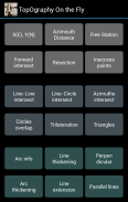
Task list:
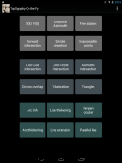
Direct geodetic problem
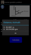
Inverse geodetic problem
Two points resection – Free station
Simple forward intersection
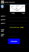
Simple resection
Inaccessible points
Line-line intersection
Line-circle intersection
Azimuths intersection
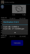
Circles overlap
Trilateration
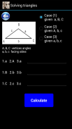
Triangles computation – three cases
Arc details
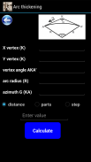
Arc thickening
Line thickening
Line extension
Perpendicular line
Parallel lines
Inaccessible height
Inaccessible base
Tacheometry
Polygon area
Trigonometric leveling
Great tool for land surveyors, civil engineers, topographers and land engineers.
Download also our free application:
"Geodetic NET" from Google play
https://play.google.com/store/apps/details?id=com.GeodeticNET&hl=en
"Surveying In the Field" from Google play
https://play.google.com/store/apps/details?id=com.Surveying.IntheField&hl=en
Don't forget to rate this app and send us a feedback.</br></br></br></br></br></br></br></br></br></br></br></br></br></br></br></br></br></br></br></br></br></br></br></br></br></br></br></br></br></br></br></br></br></br></br></br></br></br></br>
Topography On the Fly - Versão 5.37 ML
(03-08-2017)Topography On the Fly - Informações do APK
Versão do APK: 5.37 MLPacote: com.TopOgraphy.OntheFlyÚltima versão de Topography On the Fly


Apps na mesma categoria


Você também poderá gostar...


